
Between August 28th and October 1st, 2025, the EMLab participated in the "Section as Cosmogram: From the Heavens to the Earth" exhibition at Ithaca College, curated by David Salomon. Image courtesy of Handwerker Gallery, Ithaca College.
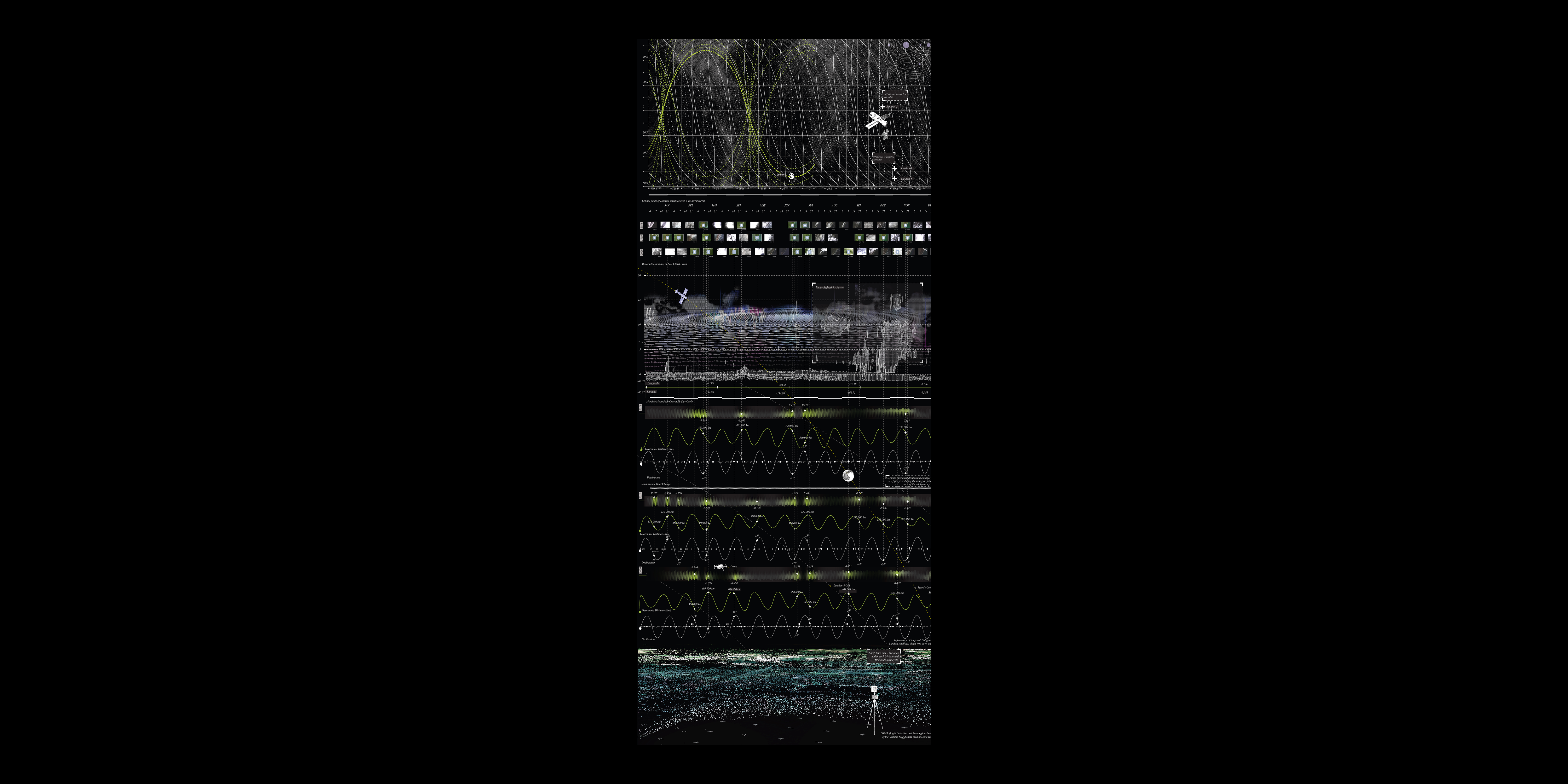
Our exhibited drawing depicts Jenkins Sound, New Jersey, and the temporal alignments and misalignments between natural processes and the technologies we use to understand them.

Landsat satellites make a complete orbit around the earth every 99 minutes and cross every point on Earth every 16 days.
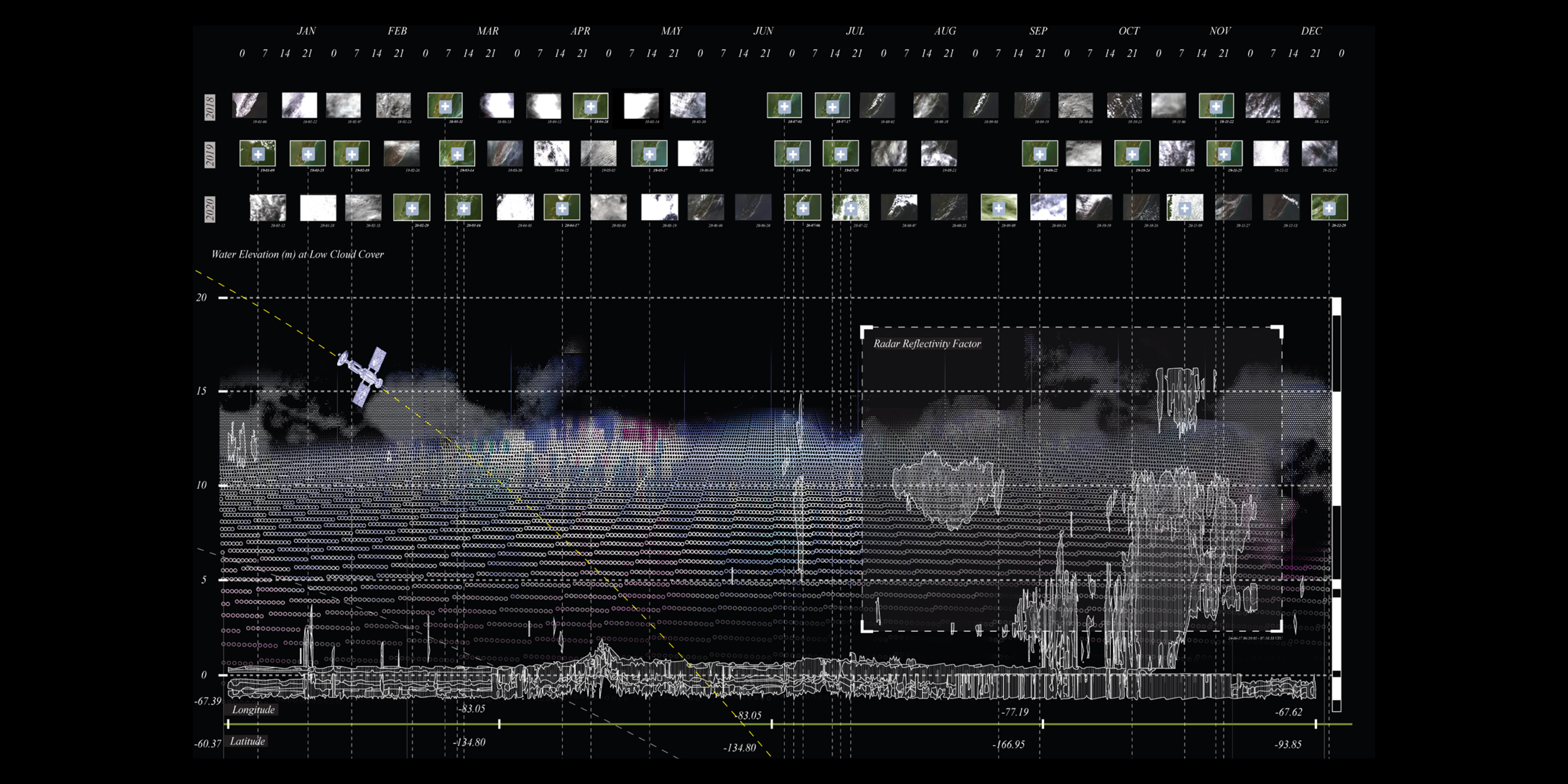
Landsat satellite data is often obscured by cloud cover and complicated by variable tide levels.

Variable gravitational forces, resulting from the relative positions of the Sun, Moon, and Earth, cause tides to fluctuate to levels much higher or lower than recorded averages.

Jenkins Sound, New Jersey, is a tidal salt marsh environment that is highly impacted by subtle changes in tides and sea levels, making the process of mapping land-water boundaries both important and complex.
Cosmogram Exhibition: Behind The Scenes
Our exhibited drawing depicts Jenkins Sound, New Jersey, and the temporal alignments and misalignments between natural processes and the technologies we use to understand them.
The land-water boundary depicted on maps does not exist as a fixed point in space or time; however, it serves as a crucial reference for measuring changes, especially in the context of rapid climate change. Land-water datums are established through a combination of on-site measurements (such as tide levels), statistical analyses of these measurements over time, and interpretations of satellite and aerial imagery. This is a fraught exercise given that everything is in continuous motion. The cycles of tides, influenced by the moon’s orbit, do not synchronize with satellite orbits. Clouds obscure the satellite’s gaze. Variable gravitational forces, resulting from the relative positions of the Sun, Moon, and Earth, cause tides to fluctuate to levels much higher or lower than recorded averages, which are themselves statistical conventions that obscure the “outliers.”
"[Mediation] is not the neutral process of the interaction of separate forms, but an active process in which the form of the mediation alters the things mediated, or by its nature indicates their nature." – Raymond Williams
Led By: Karen M’Closkey and Keith VanDerSys
Project Team: Andreina Sojo
© 2020 University of Pennsylvania Stuart Weitzman School of Design
© The Ian L. McHarg Center for Urbanism and Ecology
210 South 34th Street
Philadelphia, PA 19104
© 2020 University of Pennsylvania Stuart Weitzman School of Design
© The Ian L. McHarg Center for Urbanism and Ecology
Office of the Director
210 South 34th Street
Philadelphia, PA 19104